Lighthouses
of the
Quoddy Loop
Active Light Station Preservation Projects
are indicated with a red asterisk (*).
Blacks Harbour, NB
Bliss Island, NB
Calais, ME
Campobello Island, NB
|
Cherry Island, NB
Cutler
Deer Island, NB
Grand Manan, NB
|
Letete, NB
Lubec, ME
White Head Island, NB
Wolf Islands, NB
|
Quoddy Loop Active Lighthouse Preservation Efforts
Other Lighthouse Resources
See © Copyright Notice at Bottom of Page
Blacks Harbour, New Brunswick
This lighthouse and the lighthouse on The Wolf Islands are a familiar site to passengers on the Grand Manan Island ferries.
Top of Page
Bliss Island, New Brunswick
 ©
©
Bliss Island Lighthouse
Top of Page
Calais, Maine
![[Whitlock Mills Lighthouse]](images/lighthouses/whitlock_mill_sm.jpg)
Whitlock's Mill Lighthouse*
This is the northernmost light in Maine. In 1892, a red lantern was hung on a tree here, and tended by Mr. Whitlock who had a lath mill nearby. In 1909 the current light (light is publicly accessible) -- the last one built in Maine -- was erected, along with the bell tower (fog signal) and the keeper's residence (keeper's house is not publicly accessible).
The tower is brick, painted white, on a granite foundation, and lined inside with white enamel brick. It is 12 feet in diameter at its base, and is 25 feet in height, rising 29 feet above mean high water. Inside, access to the top is via cast iron steps. The octagonal lantern area has a narrow iron walkway outside. Operation of the light is now automated.
The pyramid-shaped, wood-shingled bell house is adjacent to the light, although the bell no longer resides inside.
The keeper's house (not publicly accessible) is two-story, stuccoed, and with a gambrel roof. The oil house is of brick construction, and there is a wood-shingle sided hip-roofed shed.
The light was automated in 1969.
* The light tower is now owned and maintained by the St. Croix Historical Society, Calais. All other property on the original station is privately owned. Access to the light tower, 3 miles from Calais on US-1 south, is a short walk from the main road or can be viewed from the nearby roadside turnout (Pike's Park) on US Rt-1.
* Lighthouse Preservation Effort: St. Croix Historical Society
Top of Page
Campobello Island, New Brunswick
 ©
©
Mulholland Point Light
This little lighthouse, built in 1885, resides within the Roosevelt-Campobello International Park property near the F.D. Roosevelt Memorial International Bridge.
Overlooking Lubec Narrows, the town of Lubec, a lobster pound, and including a picnic area, it provides a wonderful view, with a good chance of sighting seals in the channel.
Both the Mulholland Light and the Lubec Channel Light can be seen from this area.
 ©
©
Head Harbour (East Quoddy Head) Lighthouse*
On a separate, tiny island at the furthest point north on Campobello Island, this wonderful lighthouse, constructed in 1829, and painted with the Cross of St. George, offers visitors an exceptional experience. The fog alarm building was constructed in 1914 - 1915.
During the season, you're apt to see whales feeding offshore. If they're close enough, and the wind is blowing in the correct direction, the whales' spouting can even be heard.
At least three other lighthouses can be spotted by the sharp eye from this vantage point: L'Etete Passage (Green's Point) Lighthouse in St. George, the small Leonardville Light on Deer Island, and on the Wolf Islands (The "Wolves").
Far off shore lies the car ferry route between Blacks Harbour and Grand Manan Island. Visitors to East Quoddy Light are apt to see one--or both--ferries and they steam the 13 miles (2-to-2.5 hours) between the mainland and the large island at the mouth of Fundy Bay.
Although it's dangerous and rugged, for about two hours when the tide is out, the hearty and adventuresome visitor can climb the steep, slippery metal ladders, walk on the ocean floor. Then, across two intermediate islands--connected by a short, wooden bridge--and once again down a steep ladder to cross a rocky, wet, seaweed-covered intertidal zone, and then finally out to the lighthouse itself!
DANGER!--TAKE NO RISKS & DO NOT LINGER! If you become stranded on the islands by the tide, WAIT FOR RESCUE. Even former keepers of this lighthouse have lost their lives by misjudging the STRONG, FRIGID, FAST-RISING tidal currents, and TIDE-PRESSURIZED UNSTABLE PEBBLE OCEAN FLOOR, while attempting to make this crossing. (During a summer in the 1990s, two visitors attempted to swim across this passage. One made it across, but the other was swept away by the current. After a rescue by boat, both had been stricken with hypothermia, were rushed to the hospital -- and luckily, survived.)
Top of Page
Cherry Islet, New Brunswick
 ©
©
Cherry Islet (Island) Light
(Small light on tiny Cherry Islet, to the south of Deer Island.)
NOTE: Coast Guard Canada has since demolished the outbuildings and repainted the tower.
This photograph will be updated in the future.
Visible from the Eastport municipal pier, and from North Road on Campobello Island, this little lighthouse sit like a small jewel on Cherry Islet. It was established in 1824.
Top of Page
Cutler, Maine
On Little River Island near the mouth of Cutler Harbor, this light stands guard. Boat excursions and aircraft make it possible to view Little River Light. It was first constructed in 1847, but was rebuilt in 1876, and was automated in 1975.
The tower is brick-lined cast iron, and is 41' tall.
Top of Page
Deer Island, New Brunswick
Leonardville Light
Just south of Leonardville along NB Route 772, amongst the trees, is the little Leonardville Lighthouse. From this lighthouse, looking straight outward, lies Head Harbour Lighthouse just off the northern tip of Campobello Island.
A short footpath leads from the highway to the Leonardville Light. DANGER!--There is no rail along the precipitous cliff along which the lighthouse is situated!
Deer Point Beacon
A white tower with red light stands at Deer Point at the south end of the island, within Deer Island Campground, overlooking Eastport, Maine, and Old Sow Whirlpool.
Top of Page
Grand Manan, New Brunswick
(See also "White Head Island" below--a short ferry ride from Ingall Head, Grand Manan)
- Long Eddy Point Lighthouse (at the north end of Grand Manan).
 ©
©
-
- Swallow Tail Lighthouse (North Head).
- Southwest Head Lighthouse (at the south end of Grand Manan).
- Great Duck Island Light (to the east of Grand Manan).
- Gannet Rock Light (to the south of Grand Manan).
- Constructed in 1831 and automated in 1996.
- Octagonal wood construction.
- Machias Seal Island Light (equidistant from Grand Manan, NB, and Cutler, ME).
NOTE: While this is a Canadian-built and -staffed light, and while Canadian Wildlife officers staff the island during the summer, Canada and the United States both lay claim to Machias Seal Island. Ironically, this island's nationality was not resolved by the Treaty of Ghent after the War of 1812 and was not addressed later that century by the Webster-Ashburton Treaty of 1842, which decided the disputed boundary between northern Maine and New Brunswick, and between the two countries in the Great Lakes region. Since the Paris Treaty of 1873 following the American Revolution against Great Britain, no definitive decision has been made as to Machias Seal Island's nationality. (Refer to the CIA World Factbook's Canada page "Transnational Issues" and / or the CIA World Factbook's USA page "Transnational Issues". See also, Gulf of Maine Times 1997 article, "Machias Seal Island: US and Canada collaborate on bird sanctuary management despite sovereignty dispute.")
Top of Page
L'Etete, New Brunswick*
L'Etete Passage Light
(Greens Point Light)
The keeper's house of Letete Passage Light, also known as Greens Point Light, is now the Green's Point Lighthouse Museum! The museum is home to several small aquaria, including a touch tank, and has such things in its collection as a 2000 year old walrus skull!
Coming from Letete, continue past the last turnoff to the Deer Island Ferry landing, until you reach the lighthouse. From this vantage point one can also see Head Harbour Lighthouse just off the tip of Campobello Island.
* Lighthouse Preservation Effort: Green's Point Light Association
Top of Page
Lubec, Maine
 ©
©
Other Images
West Quoddy Head Lighthouse*
Standing attention at the eastern edge of the United States, this candy-striped lighthouse protects vessels from the rocky shore and shoals of West Quoddy Head, while looking across the water to Liberty Point on Campobello Island (about 1.25 miles away) and Grand Manan (about 9 miles away).
Construction of the light was authorized in 1806 by Thomas Jefferson, and the original tower was completed and put into service in 1808. In 1858, the tower was replaced with the current one along with construction of the keeper's house, and a third order fresnel lens--still in use today--was place in it at that time. It was automated in 1988. The light is constructed of brick, on a masonry foundation, is 49 feet high, and protrudes 83 feet above average sea level.
There is a fog horn building on the grounds which was constructed of brick in 1887. Also, the wooden Victorian-style keeper's quarters were built in 1858. The oil house was built in 1892.
The current tower has 15 stripes--8 red and 7 white. 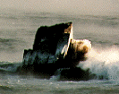
The light is leased to West Quoddy Lighthouse Keepers Association of Lubec, Maine.
Sail Rock (©, right), protruding from the Bay of Fundy, is the small rock just a few yards offshore from West Quoddy Head Lighthouse, and is the eastern-most bit of terra firma in the U.S.A.
Quoddy Head State Park, with hiking trails and picnic area, adjoins the lighthouse property. During the season, whales are frequently seen offshore in Grand Manan Channel of the Bay of Fundy.
* Lighthouse Preservation Effort: West Quoddy Head Light Keeper Association
Lubec Channel Light
The Sparkplug
Established in 1890, this light is also known as the "Sparkplug." Construction is brick-lined cast iron, and has been recently restored. The 53 foot tower stands guard in the middle of Lubec Channel between Lubec and Campobello Island. It was automated in 1939.
Both this light and the Mulholland Light on Campobello Island can be seen from the F.D. Roosevelt Memorial International Bridge which connects these two communities.
Top of Page
St. Andrews, New Brunswick
St. Andrews Lightstation
The Pendlebury Light
Indian Point Light
Built and commissioned in 1833, this light has had several close calls. A tidal surge in 1869 (the Saxby Gale) and another in 1873 nearly carried the diminutive light away. It was moved in 1874, due to the seawall having collapsed; was moved again in an unknown year; and again in 1876. In 2002, after it was moved 50 feet away, its surroundings' protective cribbing disintegrated in a winter storm.
As of February 2004, the rare early-colonial wrought iron lantern -- containing four oil lamps that burned whale and porpoise oil, providing a fixed white beacon -- was removed for restoration.
* Lighthouse Preservation Effort: St. Andrews Civic Trust's Pendlebury Lighthouse Project
Top of Page
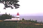
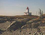
White Head Island, New Brunswick
(See also "Grand Manan" above.)
 ©
©
Long Point Light
Long Point Light, along a pebble trail that--due to the action of high and rough winter seas--can be in impassible condition until the road is graded in the summer. This diminutive light at the mouth of the Bay of Fundy faces out toward the Gulf of Maine, with the open Atlantic Ocean, beyond.
Top of Page
Wolf Islands, New Brunswick
 ©
©
Southern Wolf Island Light
The lighthouse at the Wolves can be seen in the distance from East Quoddy Lighthouse on Campobello Island.
Top of Page
* Active Quoddy Loop Light Station Preservation Projects
- Calais, ME
- St. Croix Historical Society, P.O. Box 242 , Calais, Maine 04619 (207) 454-2604
-
- Campobello Island, NB
- Friends of Head Harbour Lightstation
Head Harbour Lightstation Preservation Effort Photographs
-
- Cutler, ME
- Little River Light
-
- Letete, NB
- Green's Point Light Association
-
- Lubec, ME
- West Quoddy Head Light Keeper Association
St. Andrews, NB
Pendlebury Lighthouse Project
Other Lighthouse Resources
Top of Page
Photograph Copyright Notice
Unless otherwise indicated, Photographs Copyright © 1996, 1997, 1998 Old Sow Publishing
Other photographs are copyrighted as indicated in their respective copyright notices.
Top of Page

|
Site Comments or Suggestions?
|
|

